Map of South America
Map of South America > History | Travel Tips |
Relief Map | Topo Map
 |
South America Map Navigation
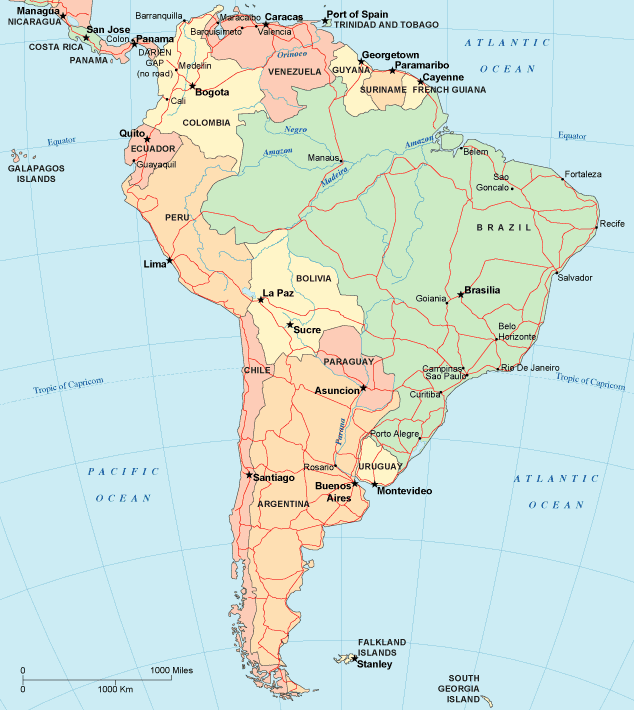
To display the map in full-screen mode, click or touch the full screen button. To zoom in on the South America political map, click or touch the plus (+) button; to zoom out, click or touch the minus (-) button. To scroll or pan the zoomed-in map, either (1) use the scroll bars or (2) simply swipe or drag the map in any direction. (The scrolling or panning method you use will depend on your device and browser capabilities.) At any time, you can display the entire South America map in a new window or print this page, including the visible portion of the map.

South American Travel and Tourism > SA Travel Destinations
South America is a land of great contrasts. Its landscapes vary from the tropical Amazon river basin in northern Brazil to the dry Atacama Desert in northwest Chile. The Andes stretch along the west coast and contain numerous mountains over 18,000 feet high. Lake Titicaca, covering 3,220 square miles in the Andes, is the world's highest navigable lake. To the east lie lowlands in the center of the continent, the Brazilian Highlands along the east coast, and vast grasslands stretching south into Argentina.The largest city in South America is Sao Paulo, Brazil; other leading cities include Buenos Aires, Rio De Janeiro, Caracas, Santiago, and Lima. Air travelers to South America can fly on American Airlines or United. The Pan American Highway, designed to promote trade and mobility between South America and North America, is not yet completed for several miles through eastern Panama. BBC's Latin America News provides online news and analysis of events in South America and Central America.
South America History and Antique South America Map
This South America history page provides an overview of South American history and culture from ancient times to modern times. This vintage map of South America shows the continent of South America as it appeared in a 19th century atlas.Related Continent Map Sites
- Map Of Antarctica - Antarctica maps and geography.
- Map Of North America - NA maps and travel info.
All rights reserved. About us.
Certain maps hereon are © Map Resources.